 Deutsch
 English
 中文
中文
 Danish
 Eesti
Eesti
 Español
 Suomi
Suomi
 Français
 Italiano
 日本語
日本語
 한국
한국
 Nederlands
 Norge
Norge
 Polski
 Portugues
 Русский
 Svenska
 Türkçe
 العربية
 Romanesc
 български
From a "suburb of modernity" to a metropolis in Lower Saxony
Hannover in Transition
The history of the city of Hannover spans from its medieval origins through its time as a royal seat to Hannover City 2020+.
As the capital of Lower Saxony, Hannover is now one of Germany’s leading cities. The black-and-white map shows the city in 1916, while the color map to its right is a current view. By holding down the mouse button, you can zoom in and out of the black-and-white map using the white button, allowing you to see how the cityscape has changed over time. By the end of World War II, not only the Old Town and Calenberger Neustadt, but also large parts of the adjacent North, East, and Südstadt districts lay in ruins. Following the destruction, the reconstruction phase began. City Planning Director Rudolf Hillebrecht designed the downtown area with wide streets and green spaces. The Marktkirche was rebuilt in 1946 as a defining landmark. In the 1950s, today’s government district emerged in the area around Waterlooplatz. The Ihme-Zentrum was completed in 1975 in the Brutalist style. Hannover’s newly gained centrality following German reunification and the Expo 2000 world’s fair provided significant impetus for urban development. The revitalization of the area around the main train station is one example of this. Aegidientorplatz has also changed following the removal of the elevated highway in 1999. The new Nord/LB building on Friedrichswall also makes a dominant statement.
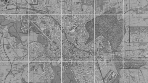
Map of Hannover, 1914
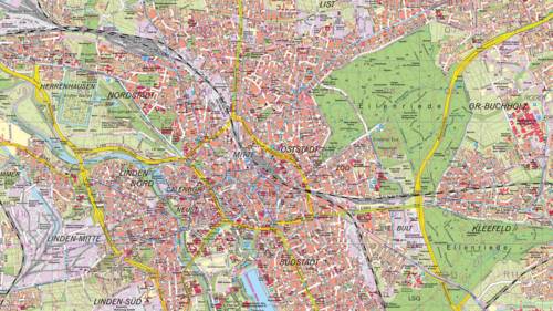
Map of Hanover Today